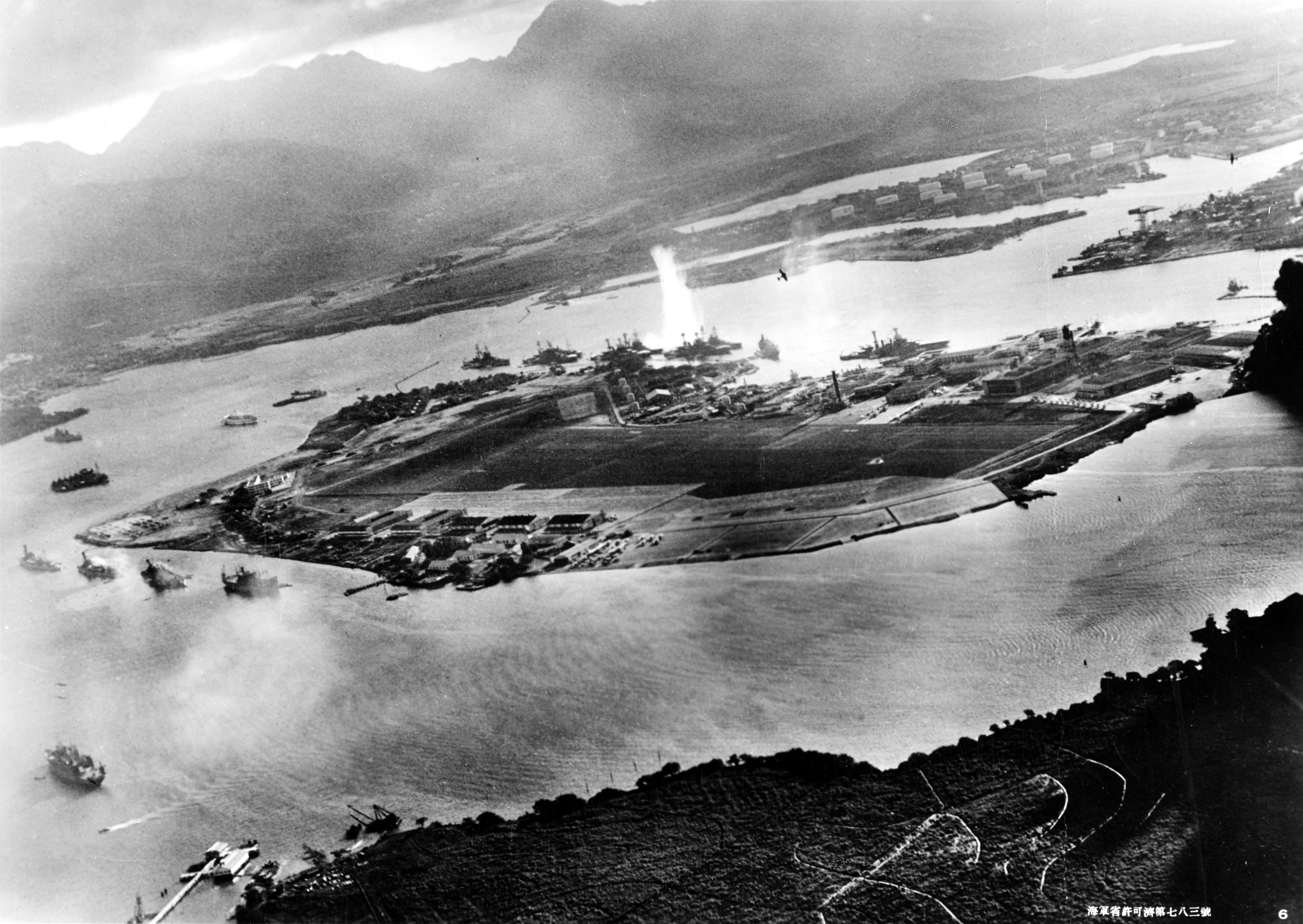
Friday, December 7, is the 71st anniversary of the Japanese attack, "a date which will live in infamy." Although it is commonly referred to as Pearl Harbor Day, numerous military sites were attacked throughout Oahu. Yet the most visible damage and highest human loss occurred in Pearl Harbor. Above is an aerial view of Pearl Harbor from a Japanese Zero. The image was published by the Government of Japan and it is considered public domain.

The map above was created by 'anynobody' and posted on Wikipedia, giving permission to copy per the GNU Free Documentation License. It provides an excellent overview of the Japanese attack. Go to the link for the legend to the letters and numbers. This coming week, we'll explore the sites I have visited:
- Monday: Opana Radar Station
- Tuesday: Kaneohe Naval Air Station
- Wednesday: Bellows Field
- Thursday: Hickam Field
- Friday: Pearl Harbor and Ford Island
- Saturday: The Mighty Mo, marking the end of WWII

My inlaws are history buffs and I drove them up to the Army's Opana Radar Station. It is located at the most northern tip of Oahu. These markers are open to the public at Turtle Bay Resort, sitting at the foot of the volcanic mountain where the radars are erected.

The National Geographic website offers a timeline for December 7. From the link,
0702 hours The Army’s Opana Mobile Radar Station is one of six radar stations on Oahu. Radar is a new defense tool in Hawaii; the system has been in operation for less than a month.
One of the two privates on duty looks at the radar oscilloscope and can’t believe his eyes. He asks his buddy to take a look—and he confirms the sighting: 50 or more aircraft on a bearing for Oahu. The privates call the Fort Shafter information center, the hub of the radar network.
0720 hours An Army lieutenant who is in training at the radio-network operations center at Fort Shafter gets the Opana radar station report: “the biggest sightings” the radar operator had ever seen. By now the planes are about 70 miles (113 kilometers) away. The lieutenant believes that the radar had picked up a flight of U.S. B-17 Flying Fortress bombers heading from California to Hawaii. For security reasons, he cannot tell this to the radar operators. All he says is, “Well, don’t worry about it.”

Today, the Army still maintains the radar station. Imagine the sight when surfers catch a wave into Turtle Bay!

The Turtle Bay Resort marks the east end of the North Shore. It is famous for its renowned golfing, snorkeling, and, of course, surfing. Mahalo to my inlaws for the above pictures (I assume they are royalty free).

The surf roars to life along the volcanic coast!

A few surfers venture into the rough waters.

Driving west, the North Shore gives way to public beaches that are packed during the surf season - Sunset Beach, Banzai Pipeline (Ehukai Beach), Shark's Cove, Pupukea Beach, and Turtle Cove (Laniakea Beach). Here's a link to a map of Oahu's North Shore.
This week's comments are open forum. One randomly selected commenter from this week's blogs wins a book choice from my convention stash. This giveaway is open to all readers. Comments are open through Saturday, December 8, 10 pm in Hawaii. I'll post the winner on Sunday, December 9, on SOS Aloha.
Mahalo,
Kim in Hawaii

Turtle Beach is famous for the honu (turtles).
Tourist can take pictures but must not touch the honu.
Turtle Bay is aptly named.
ReplyDeleteHi Kim - Interesting post! That poor Lieutenant at Ft Shafter... Anybody who's been a Lt knows how much you want to learn quickly and try not to make "rookie mistakes"...that happened to be a huge one. Of course, I don't believe, at the time, that anyone in the US thought that we'd ever get attacked...
ReplyDeleteAloha, Lacey! Perhaps that day taught Lt Tyler something ... as he went on to have an illustrious career in the AF as a fighter pilot, test pilot and Korean War vet. Still, he will forever be known for his untimely utterance on the morning of Dec. 7, 1941.
DeleteMost "students of history" today believe the few added minutes of time involved would not have changed much. With the majority of planes lined up on tarmacs on the major airfields, and pilots scattered around over the weekend, very few extra fighter planes could have become airborne in time to do any good. the mostly P-40s and the few other assorted fighters were ot equal tothe A6M the japanese had, and given the preparation the Japanese had, they were ready for some opposition anyway.
DeleteOne more comment... is the radar station there now operated by the Army or the AF... most radar sites went to the AF when the AAF became a separate service in 1947. I know, I was AF ground radar maintenance from 1961 to 1965.
I would love to see Turtle Beach and again wonderful pictures.
ReplyDeleteIf only the Lieutenant had told somebody else, history would have been so different.
ReplyDeleteLove the pics, and the Turtles are so cute. The same goes here in Florida, you can look at them, but you'd better not touch them - or else!!!
Wow... love the turtles... You can't see them anywhere in Canada!
ReplyDeletePearl Harbor, Turtles, Volcanoes, Beaches, Hula only in Hawaii! <3
ReplyDeleteAll very interesting. I would love to be able to see the turtles!
ReplyDeleteWould love to see the turtles on Turtle Beach!
ReplyDeleteSome people told me if you touch the turtles they could contract an illness from you.
ReplyDeleteLove the turtles. Seeing their photo makes me smile.
ReplyDeleteOh cute turtles
ReplyDeleteKimh
Thank you for all the beautiful photos! I would so love to visit Hawaii someday!
ReplyDeleteGreat pics! Would have loved to see the turtles in person!
ReplyDelete